...
>
UAV LiDAR System
(67)
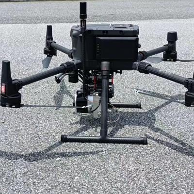
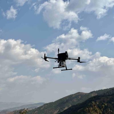
Drone Lidar Scanner Geosun GS-130X 3D Scanning Built-In RGB Camera Total Aerial Solution DJI M300 Cost Effective
Price: Negotiation
MOQ: 1
Delivery Time: 10-15 works days
Brand: Geosun
High Light:1.6 Km2 UAV Lidar Systems, HESAI XT UAV Lidar Systems, HESAI XT uav lidar sensor
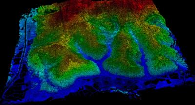
Drone Lidar Scanner Geosun GS-130X 3D Scanning Built-In RGB Camera Total Aerial Solution DJI M300 Cost Effective Application of UAV LiDAR Scanning System Drone with LiDAR ( DJI M300 and GS-130X) Free trial software of uav LiDAR Scanning System Trial Software Information.pdf Point Cloud Pre-Processin... View More
➤ Visit Website
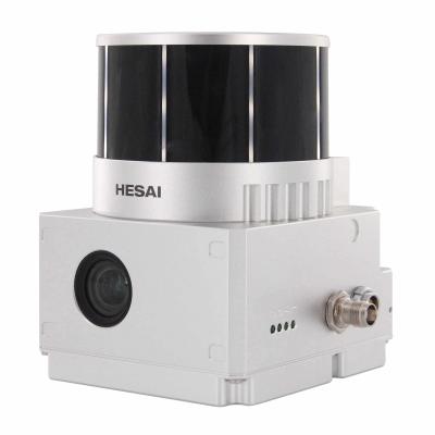
Geosun GS-260X UAV LiDAR Scanning System HESAI XTM2X Sensor High Accuracy Terrain Mapping UAV Surveying
Price: Negotiation
MOQ: 1
Delivery Time: 10-15 works days
Brand: Geosun
High Light:1.9kg LiDAR Scanning System, M600 PRO LiDAR Scanning System, 1.9kg 3D Surveying LiDAR Scanning System
GS-260X LiDAR Scanning System HESAI XTM2X Sensor High Accuracy Terrain Mapping UAV Surveying Geosun gAirHawk Series GS-260X LiDAR Scanning System gAirHawk GS-260X is a kind of Mid-range, compact LiDAR point cloud data acquisition system, integrated HESAI HESAI XTM2X laser scanner, GNSS and IMU posit... View More
➤ Visit Website
Fixed Wing Drone UAV LiDAR GS-130X HESAI XT32 Sensor 1.26KG 3D Mapping Strong Penetration Forestry Powerline Surveying
Price: Negotiation
MOQ: 1
Delivery Time: 10-15 works days
Brand: Geosun
High Light:GS-130X LiDAR Scanning System, Pandar XT Sensor LiDAR Scanning System, HESAI XT Sensor UAV Scanning System
Fixed Wing Drone UAV LiDAR GS-130X HESAI XT32 3D Mapping Strong Penetration Geosun gAirHawk Sesries GS-130X uav LiDAR Scanning System LiDAR Scanning System GS-130X integrates a Hesai XT32 laser sensor and all built-in units to create a futuristic look for your diversified LiDAR solution services.Sta... View More
➤ Visit Website
GS-100E UAV LiDAR Scanning System With Integrated Multispectral Camera Geosun
Price: Negotiation
MOQ: 1
Delivery Time: 10-15 works days
Brand: Geosun
High Light:GS-100E UAV LiDAR Scanning System, LiDAR Scanning System With Geosun, GS-100E uav lidar scanner
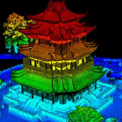
UAV LiDAR Scanning System with Integrated Multispectral Camera Geosun GS-100E LiDAR Scanning System Application for 3D Surveying and Mapping GS-100E is a UAV measurement system independently developed by Geosun Navigation. It highly integrates laser scanner, GNSS satellite positioning system, INS in... View More
➤ Visit Website

DJI Drone Mount LiDAR Scanning System With Livox Avia Laser Sensor
Price: Negotiation
MOQ: 1
Delivery Time: 7-10 works days
Brand: Geosun
High Light:Livox Avia Laser Sensor LiDAR System, DJI M210 LiDAR Scanning System, 4km2 LiDAR Scanning System
gAirHawk GS-100C+ LIDAR SCANNING SYSTEM Drone LiDAR Scanning System Mounted on DJI Drone with Livox Avia Laser Sensor and Build-in Camera gAirHawk GS-100C+ is a kind of light compact LiDAR point cloud data acquisition system, integrated Livox new generation laser scanner, GNSS and IMU positioning an... View More
➤ Visit Website

Forestry 3D Mapping HESAI XT32 Senor UAV LiDAR GS-260X Colored Point Cloud Free Pre-Processing software High Accuracy
Price: Negotiation
MOQ: 1
Delivery Time: 10-15 works days
Brand: Geosun
High Light:2.5 Km2 UAV Lidar Systems, HESAI Pandar UAV Lidar Systems, 2.5 Km2 uav lidar mapping
Forestry 3D Mapping HESAI XT32 Senor UAV LiDAR GS-260X Colored Point Cloud Free Pre-Processing software High Accuracy UAV LiDAR Scanning System GS-260X integrates Hesai XT32 laser sensor and all built-in units to create a futuristic look for diversified LiDAR solution services. Stands out with stron... View More
➤ Visit Website
3D Data Livox Avia LiDAR
Price: Negotiation
MOQ: 1
Delivery Time: 7-10 works days
Brand: Geosun
High Light:3D Data Livox Avia LiDAR, Geosun LiDAR, 450m Livox Avia LiDAR
gAirHawk GS-100M+ LIDAR SCANNING SYSTEM LiDAR Scanning System with 3D Data Livox Avia Laser Sensor gAirHawk GS-100M+ is a kind of light compact LiDAR point cloud data acquisition system, integrated Livox new generation laser scanner, GNSS and IMU positioning and attitude determination system, and st... View More
➤ Visit Website

Terrain Mapping Aerial Surveying Geosun UAV LiDAR System GS-130X High Precision
Price: Negotaible
MOQ: 1
Delivery Time: 7-10 work days
Brand: Geosun
High Light:Aerial Surveying UAV LiDAR System, GS-130X UAV LiDAR System, Terrain Mapping UAV LiDAR System
Terrain Mapping Aerial Surveying Geosun UAV LiDAR GS-130X High Precision Cost-Effective Cost Highly Integration Geosun gAirHawk Series GS-130X UAV LiDAR Scanning System Drone LiDAR Scanning System GS-130X integrates Hesai XT32 laser sensor and all built-in units to create a futuristic look for your ... View More
➤ Visit Website
University Cooperation LiDAR Drone Scanner Geosun GS-100C+ High Precision IMU Colour
Price: Negotiation
MOQ: 1
Delivery Time: 10-15 works days
Brand: Geosun
High Light:LiDAR Drone Scanner Geosun, GS-100C+ LiDAR Drone Scanner, High Precision lidar 3d scanner
University Cooperation LiDAR System Geosun GS-100C+ Aerial Mapping Survey High Precision IMU Coloured Point Cloud Geosun Thailand partner have a on-site trainning at university for uav LiDAR scanning system GS-100C+. uav LiDAR scanning system GS-100C+ is the most affordable uav lidar scanning system... View More
➤ Visit Website
UAV LiDAR Scanning System GS-100C+ Livox Avia Multiple Platform Built In 26MP RGB Camera Topography Free Software
Price: Negotiation
MOQ: 1
Delivery Time: 10-15 works days
Brand: Geosun
High Light:Livox Avia LiDAR Scanning System, Multiple Platform LiDAR Scanning System, GS-100C+ LiDAR System
UAV LiDAR Scanning System GS-100C+ Livox Avia Multiple Platform built-in 26MP RGB Camera Topography Free Software Drone LiDAR Scanning System Mounted on DJI M300 , with Livox Avia Laser Sensor and Built-in Camera gAirHawk GS-100C+ is a kind of light compact LiDAR point cloud data acquisition system,... View More
➤ Visit Website

EU Airborne UAV LiDAR Scanning GS-130X Hesai XT32 Laser Senor High Accuracy Pos Colored Point Cloud
Price: Negotiation
MOQ: 1
Delivery Time: 10-15 works days
Brand: Geosun
High Light:EU Airborne Lidar Scanning, Airborne Lidar Scanning GS-130X, Hesai Xt Laser Senor Aerial Lidar Scanner
EU Airborne UAV LiDAR Scanning GS-130X Hesai XT32 Laser Senor High Accuracy Pos Colored Point Cloud Geosun gAirHawk uav LiDAR Scanning System GS-130X gAirHawk GS-130X is a kind of middle-range, compact LiDAR point cloud data acquisition system, integrated HESAI XT32 laser scanner, GNSS and IMU posit... View More
➤ Visit Website

Geosun GAirHawk Series GS-260X UAV LiDAR Scanning System HESAI XTM2X Sensor
Price: Negotiation
MOQ: 1
Delivery Time: 10-15 works days
Brand: Geosun
High Light:GS-260X UAV LiDAR Scanning System, Mapping UAV LiDAR Scanning System, HESAI XTM2X Sensor
Geosun GAirHawk Series GS-260X UAV LiDAR Scanning System HESAI XTM2X Sensor High Acuraccy Geosun gAirHawk Series GS-260X UAV LiDAR Scanning System gAirHawk GS-260X is a kind of Mid-range, compact LiDAR point cloud data acquisition system, integrated HESAI HESAI XTM2X laser scanner, GNSS and IMU posi... View More
➤ Visit Website

Uav Lidar Mapping Geosun GS-130X AGL 120m Built-In 26MP RGB Camera Strong Penetration Power Line Forestry Surveying
Price: Negotiation
MOQ: 1
Delivery Time: 10-15 works days
Brand: Geosun
High Light:32 Channel UAV LiDAR Scanner, HESAI XT UAV LiDAR Scanner, 3D LiDAR Scanning System
Uav Lidar Mapping Built-In 26MP RGB Camera Strong Penetration Power Line Forestry Surveying Geosun gAirHawk Sesries GS-130X LiDAR uav Scanning System UAV LiDAR Scanning System GS-130X integrates a Hesai XT32 laser sensor and all built-in units to create a futuristic look for your diversified LiDAR s... View More
➤ Visit Website
2.1kg 20W HESAI Pandar 40P airborne 3D Mapping Drone LiDAR Geosun GS-260F RTK Model
Price: Negotiation
MOQ: 1
Delivery Time: 10-15 works days
Brand: Geosun
High Light:HESAI Pandar 40P 3D Mapping LiDAR, 2.1kg 3D Mapping LiDAR, 2.1kg 20W airborne lidar system
2.1kg 20W HESAI Pandar 40P airborne 3D Mapping Drone LiDAR Geosun GS-260F Geosun gAirHawk Series GS-260F Drone LiDAR Scanning System gAirHawk GS-260F is a kind of Mid-range, compact LiDAR point cloud data acquisition system, integrated HESAI Pandar 40P laser scanner, GNSS and IMU positioning and att... View More
➤ Visit Website
Smart City Application UAV LiDAR System Geosun GS-130X 3D Surveying And Mapping Hesai XT32 Sensor
Price: Negotiation
MOQ: 1
Delivery Time: 10-15 works days
Brand: Geosun
High Light:M600 PRO LiDAR Scanning System, 1.26kg LiDAR Scanning System, M600 PRO lidar scanner system
Smart City Application UAV LiDAR System Geosun GS-130X 3D Surveying And Mapping Hesai XT32 Sensor Applications Of uav LiDAR Scanning System Specification of uav LiDAR scanning system uav LiDAR scanning system gAirHawk GS-130X Item Name System Parameters GS-130X Parameters Weight 1.26 kg Measuring ac... View More
➤ Visit Website
Terrain Mapping GS-260X UAV LiDAR Scanning System HESAI Sensor
Price: Negotiation
MOQ: 1
Delivery Time: 10-15 works days
Brand: Geosun
High Light:HESAI Sensor UAV LiDAR System, GS-260X UAV LiDAR System, Terrain Mapping UAV LiDAR
Terrain Mapping Height Difference 400m High Accuracy Geosun GS-260X UAV LiDAR Scanning System HESAI Sensor Geosun gAirHawk Series GS-260X uav LiDAR Scanning System gAirHawk GS-260X is a kind of middle-range, compact LiDAR point cloud data acquisition system, integrated HESAI XTM2X laser scanner, GNS... View More
➤ Visit Website
3D Tower Mapping Modeling UAV LiDAR Scanning System GS-130X
Price: Negotiation
MOQ: 1
Delivery Time: 10-15 works days
Brand: Geosun
High Light:Modeling UAV LiDAR Scanning System, 3D Tower UAV LiDAR System, Scanning System GS-130X
3D Tower Mapping Modeling UAV LiDAR Scanning System Geosun GS-130X Geosun gAirHawk Series GS-130X UAV LiDAR Scanning System UAV LiDAR Scanning System GS-130X integrates a Hesai XT32 laser sensor and all built-in units to create a futuristic look for your diversified LiDAR solution services.Stands ou... View More
➤ Visit Website

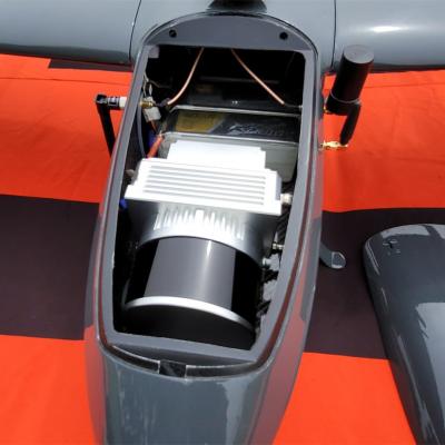
905nm 200m DJI M600 PRO Mounted LiDAR Mobile Mapping System
Price: Negotiation
MOQ: 1
Delivery Time: 10-15 works days
Brand: Geosun
High Light:905nm 200m Lidar Mobile Mapping System, 905nm Lidar Mobile Mapping System, Geosun 905nm LiDAR Mobile Mapping System
gAirHawk GS-260F UAV LIDAR SCANNING SYSTEM Drone LiDAR Scanning System Application for Mapping and Survey GS 260F Mobile LiDAR System - YouTube gAirHawk GS-260F is a kind of Mid-range, compact LiDAR point cloud data acquisition system, integrated HESAI Pandar 40P laser scanner, GNSS and IMU position... View More
➤ Visit Website
15W DJI Livox Horizon Laser Sensor GAirHawk UAV LiDAR System
Price: Negotiation
MOQ: 1
Delivery Time: 10-15 works days
Brand: Geosun
High Light:15W GAirHawk UAV LiDAR System, gAirHawk UAV LiDAR System, 15W LiDAR Scanning System
gAirHawk GS-130H UAV LIDAR SCANNING SYSTEM UAV LiDAR Scanning System with Livox Horizon Laser Sensor gAirHawk GS-130H New Designed is a kind of short range, compact LiDAR point cloud data acquisition system, integrated Livox horizon laser scanner, GNSS and IMU positioning and attitude determination ... View More
➤ Visit Website

20W 450m Mapping Surveying DJI M600 UAV LiDAR System
Price: Negotiation
MOQ: 1
Delivery Time: 7-10 works days
Brand: Geosun
High Light:20W DJI M600 UAV LiDAR System, 450m dji m600 pro lidar, 20W UAV LiDAR System
gAirHawk GS-100C+ LIDAR SCANNING SYSTEM Drone LiDAR Scanning System Mounted on DJI M600 Pro Application for Mapping and Survey gAirHawk GS-100C+ is a kind of light compact LiDAR point cloud data acquisition system, integrated Livox new generation laser scanner, GNSS and IMU positioning and attitude ... View More
➤ Visit Website